


With antennas and receivers from WRAASE electronic.
How it works:
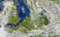
NOAA weather satellites are constantly circling the earth in a polar orbit sending down uncrypted weather images via radio signals in the VHF range. Every spot of the earth is being scanned at least every 12 hours by each satellite. You can receive these images in real time wherever you are and independently of other sources like the internet. The following components are needed:
- A special antenna which allows wide-angle reception of the satellites' radio signals.
- A special receiver which efficiently isolates the weather-satellite-signals for best image quality and sends them to a computer
- A computer/laptop with an audio-input and the special, free software "WXtoImg" installed.
- Interconnecting cables.
There may be lots of reasons for acquiring a private weather satellite readout station, but one thing is sure: Only direct reception from satellite provides accurate and realtime information of the current weather situation. It is an important tool for planning weather depending activities to avoid dangers and damages. Especially in situations and regions where other weather information sources fail, direct satellite reception remains a reliable and easy to use tool.
APT-06 - Weather Satellite Receiver
Small, reliable, uncomplicated and affordable! USB controlled and powered! Automatically receives all NOAA satellite passes! Available with antenna diversity.
Get more information
KX-137 - Weather Satellite Antenna
High-performance VHF-Weather-Satellite Antenna, with built-in low-noise preamplifier and high-Q-filter, 137-138 MHz.
Get more information